
An Op-Ed Written By: Alexander Brown
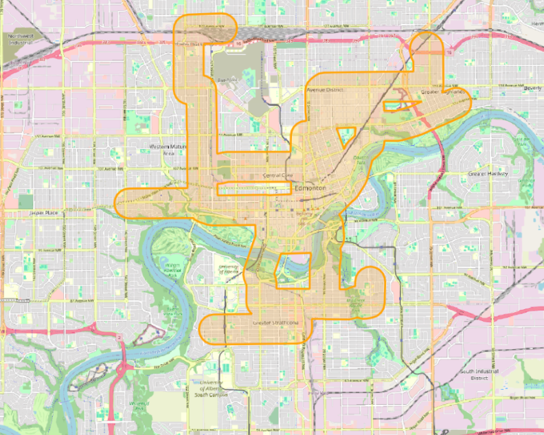
There is not much evidence anymore, but Edmonton used to have an extensive streetcar network that served the city’s first neighbourhoods. Operating from 1908 to 1951 the radial railway, or streetcar, network served many Edmontonians in their commuting needs, and served the City of Edmonton by helping to manage growth. While these streetcars haven’t been in operation for 75 years, their legacy of development remains.
When looking at 2021 federal census data one can see that the areas immediately surrounding the former streetcar lines are much more dense than other areas of Edmonton, with a 30% higher population density compared to even mature areas. While this density is perhaps to be expected, as many of the streetcar lines ran through Edmonton’s Downtown, the image below shows that even outside of the Downtown core, this density exists.
In fact, if Edmonton were built out to the same density as these streetcar areas, its population would be over 2.5 million residents, or 1.5 million within the Anthony Henday ring road.
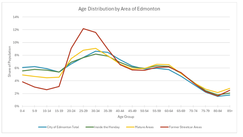
Census data in these areas surrounding the former streetcar lines also reveals interesting demographic trends. One key trend is the age of the population, 40% of the population in these areas are between 20-39 years-old, compared to 30% elsewhere in the city. Despite this higher share of young adults, there is a much lower share of children living in these former streetcar areas.
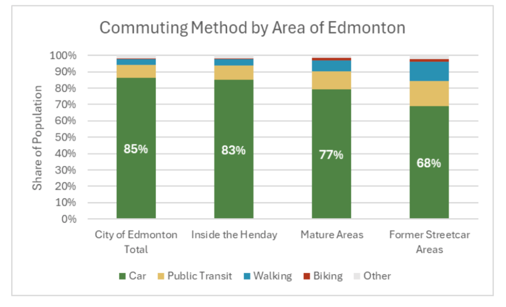
In fact, half of the households in these former streetcar areas have just one resident, and only 16% have more than two residents compared to 40% of households city-wide. The household sizes and lack of children can be perhaps explained by the current housing mix. Across Edmonton 50% of residents live in low-density housing, while in these former streetcar areas this number is less than 20%. Finally, and perhaps least surprising, residents of these denser areas enjoy shorter commute times, with 30% of residents having a commute of less than 15 minutes (compared to 23% citywide), and 74% having a commute of less than 30 minutes. Commutes are still typically made by car. However 30% of residents choose other commuting methods (public transit, biking, walking), compared to just 13% citywide.
It is perhaps not surprising to see such a high share of young adults in these dense areas which are closest to post-secondary institutions, employment centres, and abundant retail opportunities. However, the current housing stock in these areas seems to be limited when it comes to housing diversity, as young families are more frequently found living in the suburbs.
By replacing aging housing stock in these former streetcar areas with stock that is more friendly to families – in both unit size, as well as amenities offered, schools that were previously at risk of closing can stay open. As well, the need to build new schools in areas outside of the Henday is reduced. The same is true for other types of infrastructure: utility lines, fire halls, etc, as mature neighbourhoods already have this existing infrastructure, that would be millions in capital dollars to build out into new, suburban neighhbourhoods.
Please Note: Demographic data comes from 2021 federal census data at the Dissemination Area level. DAs which were partially within a given boundary (e.g., a mature area or former streetcar area) contribute proportionally to that area.